
Pipeline Track Loop
The Pipeline Track loop is an easy introduction into gravel grinds in the Otways (when it's dry).
Stats
Just shy of 25km, 646 elevation, this loop will take about 1.5 hr at an average speed of 17kmph. Most of the climbing is at the start on Roadknight Creek rd.
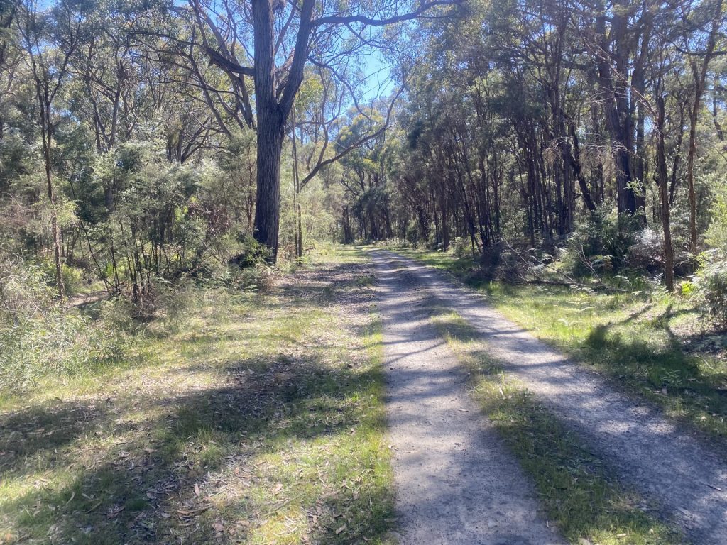
Course Terrain
You start with a few kilometres on the seal before your first taste of gravel. The climb heads up with forest on the right and a plantation on the left. This is usually a well maintained road.
Pipeline Track itself has a well formed gravel/dirt track on the right, or for those wanting more adventure, you can try riding the 4wd track on the left. The 4wd track is often full of puddles and slushy except in summer and wide tyres or a mtb go well here.
For those riding fully rigid or with skinnier/slick tyres, we suggest sticking to the more official track on the right. In the wet, there are stretches of clay even on the formed track to keep you on your toes. If your gravel tyres are fairly slick down the centre, you will most likely lose traction at some point if it's been raining recently but that just adds to the adventure. But don't worry, if you do have to walk a short section or two, it doesn't add much to the time overall.
Route Description
- Leave Forrest via Turner Drive, next to the Brewery and ride for 1.3km.
- Turn left when it intersects the Colac-Forrest Rd and ride 1.5km.
- Turn left at Roadknight Creek Rd, ride this for 5.8km.
- Take a right turn onto Ridge Rd, and follow it for 1.8km.
- Take a right-hand turn on Pipeline Track and follow it for 5.1km. Pipeline Track intersects with the Colac-Olangolah Pipeline Track, but you veer to the right at "the big sandy intersection" and continue on Pipeline.
- This comes to a T intersection with Porcupine Lane, at which you turn left.
- Ride 750m on Porcupine Lane.
- Taking the next right, you follow Boundary Rd for 6km. Take care crossing the Colac-Forrest Rd. Boundary Rd takes you past the Yaugher MTB Trail head.
- Continue on Boundary down to the main road back into town (Birregurra-Forrest Rd).
- Cross over the Birregurra-Forrest Rd to the other side and take the small piece of singletrack.
- The singletrack spits you out on the Tiger Rail Trail.
- Turn right and follow the Tiger Rail Trail back up into town for 2km.
Please note: mobile reception limited once you hit Pipeline Track.


Forrest to Lorne Return
Forrest to Lorne Return I first completed this ride on 2 Aug 2020. That morning we began to hear rumours we were going into another lockdown so instead of waiting for the doom and gloom to be announced, I got onto my bike and rode over to Lorne for my final long distance ride for … Read more

Pipeline Track Loop
Pipeline Track Loop The Pipeline Track loop is an easy introduction into gravel grinds in the Otways (when it’s dry). Stats Just shy of 25km, 646 elevation, this loop will take about 1.5 hr at an average speed of 17kmph. Most of the climbing is at the start on Roadknight Creek rd. Course Terrain You … Read more
The EC Loop
The EC Loop I’ve named the EC Loop after the local legend who rides this loop regularly for training. She can smash this out in under 2 hours… as of Sep 2020, my best time is 2:20 so still a way to go to catch her! Stats The course has 870 vert metres and my … Read more

Thompsons Loop
Thomsons Loop Stats The route is 31km long and has 830 vert metres. At an average speed of 14kmph, it will take approximately 2.5 hours. Course Terrain This loop track will take you right up into the Otway ranges, through the tall gum forests, overlooking steep mountain valleys. The first 13km is a steady climb … Read more

Kawarren Loop AC
Kawarren Loop AC The Kawarren Loop AC takes in a variety of views as you wind out of town through paddocks. Following a section of the Old Beechy Rail Trail, you will find yourself rolling down green gullies and past points of historical interest. From Kawarren East, you head back up into the dry Eucalypt … Read more

Forrest to Apollo Bay Sunnyside Down
Forrest to Apollo Bay – Sunnyside Down This is one of my favourite ways to get to Apollo Bay…. if you haven’t ridden Sunnyside Rd, you need to pop it on the list. The section leaving the Forrest-Apollo Bay Rd is just stunning forest with tall slender gums and ferns everywhere. Once Sunnyside intersects with … Read more

Barramunga Loop
Barramunga Loop This loop takes you out up Roadknight Creek Rd, but from there you head South West on Barramunga-Roadknight Rd till you reach Upper Gellibrand Road. This road would take you to Stevensons Falls if you want, but for the 20km loop, turn left which takes you back to the Forrest-Apollo Bay Rd. From … Read more

Dewings Bridge Rd Loop
Dewings Bridge Rd Loop This loop heads north of Forrest to Barwon Downs and beyond. This loop takes you out into green rolling hills and is a great loop for those seeking less vert. There is one short section on bitumen between the end of the Tiger Rail Trail and Barwon Downs so be mindful … Read more